Description
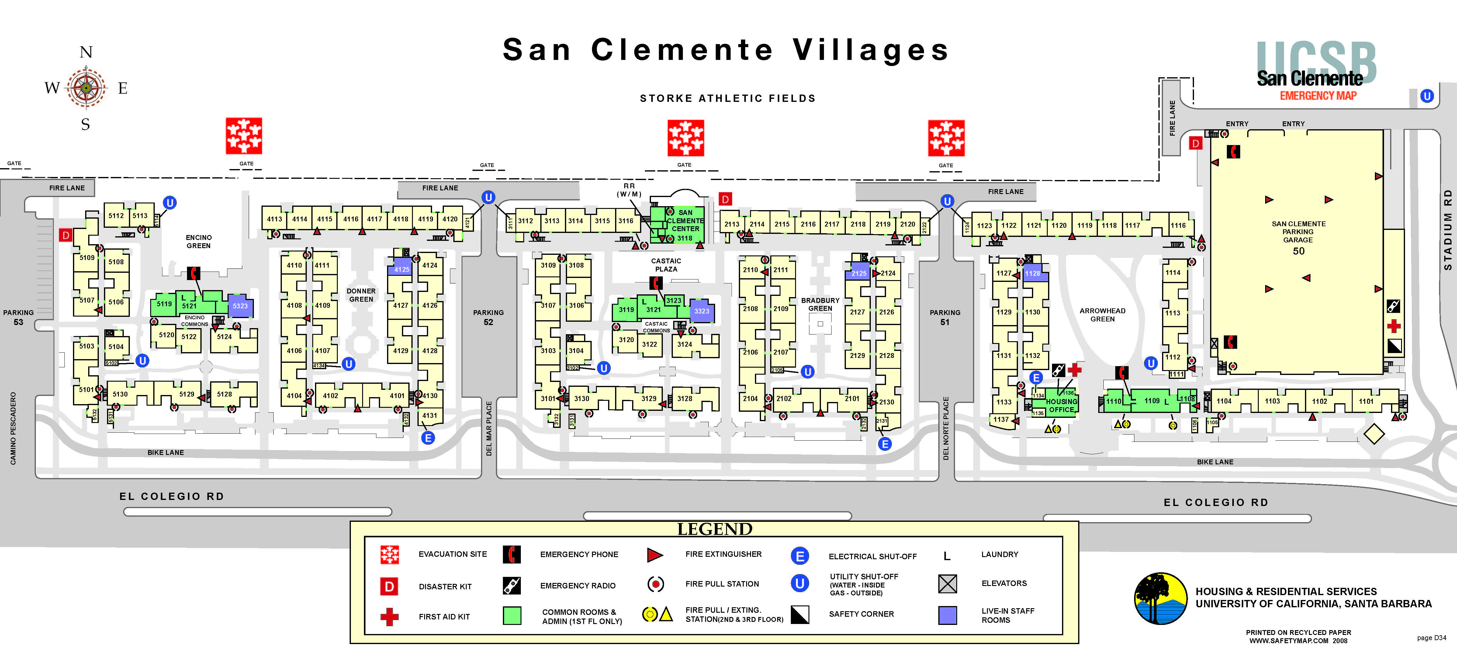
This layout map for San Clemente Villages at UC Santa Barbara provides a general layout plan of the residential complex, emphasizing building and unit numbers, pedestrian walkways, parking lots, and emergency resource locations.
Campus Orientation
The complex is located at the intersection of several key roads and landmarks:
- North: Borders the Storke Fields
- South: Bordered by El Colegio Rd.
- East: Adjacent to Stadium Rd.
- West: Bordered by Parking Lot 53
Building Layout and Residential Areas
The villages are organized into five residential clusters, each centered around a green space or plaza and alphabetically named from east to west.
- Arrowhead Village: adjacent to the parking structure 50
- Bradbury Village: adjacent to parking lot 51
- Castaic Village: east of parking lot 52 and the location of the San Clemente Center
- Donner Village: west of parking lot 52
- Encino Village: east of parking lot 53
Key Facilities include:
- Housing Office (Bldg 1133): Located in the southeast corner of the complex.
- Common Rooms & Administrative Offices: Located on the first floors only.
Emergency Evacuation Sites
There are three primary designated evacuation assembly points:
- Storke Athletic Fields (North): Residents evacuate north through various gates to the large athletic fields.
Safety and Utilities Legend
The map identifies critical infrastructure and emergency response equipment:
- Fire Safety: Fire Lane access points, Fire Pull Stations, and Fire Extinguishers are distributed throughout every building.
- Disaster Supplies: Disaster Kits (D) are located near the San Clemente Center and the Housing Office as well as First Aid Kits
- Utility Shut-offs are identified for Water, Gas, and Electrical
- Staffing: Live-in Staff Rooms are marked for immediate residential support.